-
E-mail
brand@bfdx.com
-
Phone
15659050859
-
Address
Fujian Beifeng Communication Technology Co., Ltd., Shuangyang Overseas Chinese Economic Development Zone, Luojiang District, Quanzhou City, Fujian Province
Product Categories
Fujian Beifeng Communication Technology Co., Ltd

Perimeter intrusion alarm system
NegotiableUpdate on 01/30
- Model
- Nature of the Manufacturer
- Producers
- Product Category
- Place of Origin
Overview
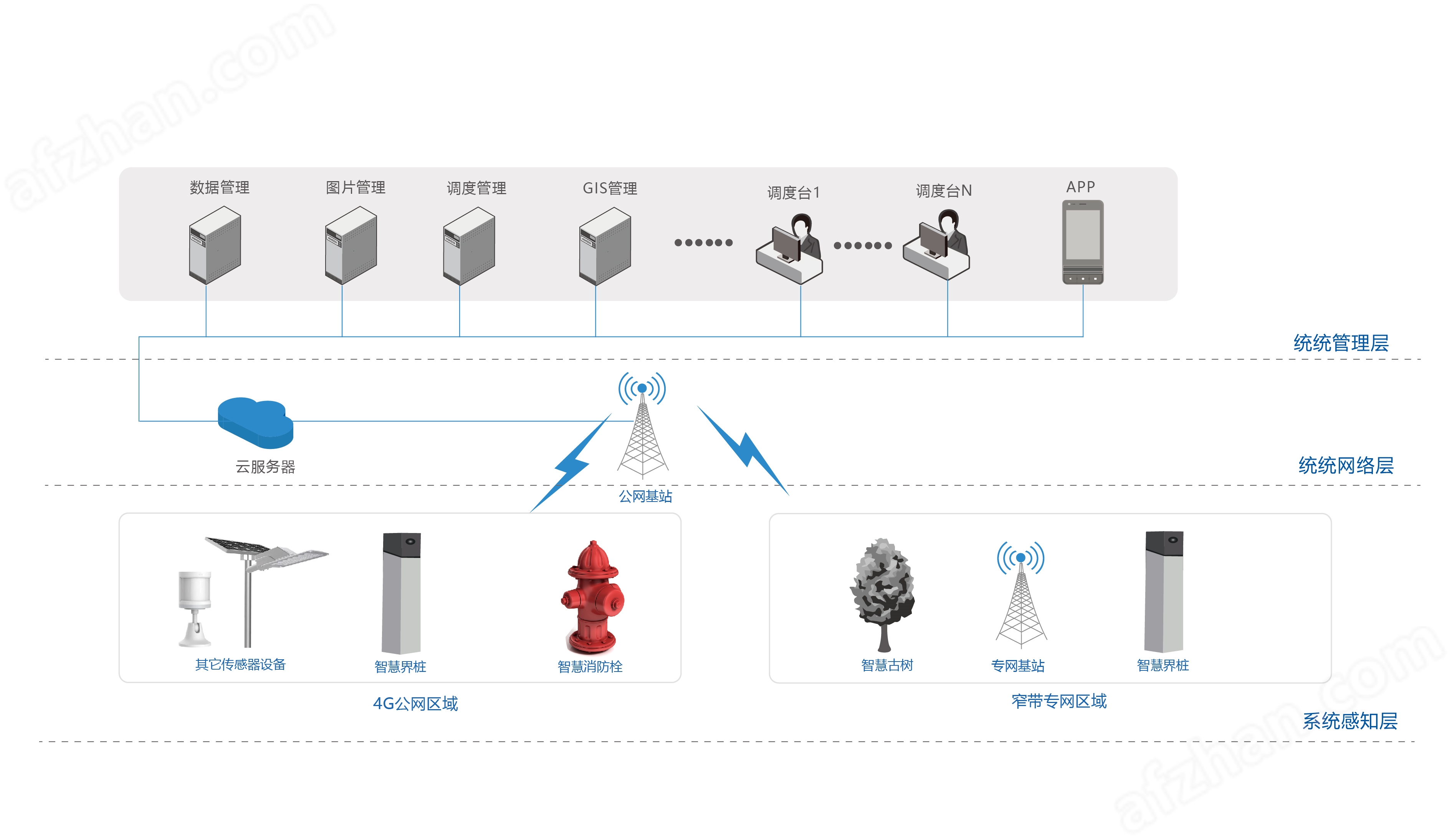
BF-PMS8110 perimeter intrusion alarm system, relying on big data cloud computing as the core support platform, deeply integrates a series of terminal sensors, wireless intercom communication scheduling, and video surveillance. By comprehensively summarizing, analyzing, and securely storing real-time data information collected from various terminals, seamless connection and close collaborative operation between multiple terminals such as PC, mobile, and monitoring centers have been achieved.
Product Details
With the development of society and economy, the protection and management of forestry resources are facing increasing challenges, such as illegal logging and cross-border development. These behaviors seriously threaten the sustainable development of related industry resources. In order to better protect and manage relevant industry resources, an efficient and accurate monitoring method is needed to monitor the status of forestry resources in real time, detect and deal with illegal and irregular behaviors in a timely manner. With the rapid development of intelligent technologies such as the Internet of Things, cloud computing, and big data, new ideas and methods have been provided for resource protection and perimeter management. As one of the specific applications of intelligent technology, smart perimeter boundary markers integrate multiple functional modules, such as Beidou positioning module, communication module, induction module, etc., which can achieve remote monitoring and real-time data transmission of forestry resources, greatly improving the efficiency and accuracy of inspection.
Three practical problems of traditional perimeter management
1. Static boundary identification, management relies on manual verification
Traditional boundary markers/posts in areas such as national defense, administrative regions, ecological circles, scenic spots, and mining areas are only used as physical signs, lacking linkage with geographic information systems. The location of boundary lines is difficult to accurately present in electronic maps, and boundaries are often blurred due to unclear markings. Underground pipeline facilities such as electricity, gas, water supply, and telecommunications are prone to boundary disputes or illegal occupation in daily management, making it difficult to detect them in a timely manner. Manual inspections require a lot of time to verify the actual boundary and drawing information.
2. Single warning capability, delayed abnormal response
Traditional boundary markers do not have real-time monitoring capabilities. When displacement, tilting, or damage occurs, they cannot actively trigger alarms and rely on regular manual inspections to detect abnormalities, resulting in time differences in problem resolution. Especially in large jurisdictional areas, the frequency of inspections is limited, and some abnormal situations may not be detected until several hours or even days later, which increases management costs and the difficulty of risk disposal.
Uneven communication coverage and blind spots in remote area management
Traditional boundary markers are located in mountainous, forested, desert and other areas with weak or no public network signal coverage. Traditional monitoring equipment cannot transmit data in real time, and management personnel find it difficult to grasp the terminal status. A single communication mode cannot meet the needs of different scenarios, resulting in some areas becoming "management blind spots", which are prone to data interruption and affect collaborative efficiency.
BF-PMS8110Perimeter intrusion alarm systemBased on the core support platform of big data cloud computing, it deeply integrates a series of terminal sensors, wireless intercom communication scheduling, and video surveillance. By comprehensively summarizing, analyzing, and securely storing real-time data information collected from various terminals, seamless connection and close collaborative operation between multiple terminals such as PC, mobile, and monitoring centers have been achieved. This system has ingeniously created a highly intelligent and comprehensive solution for the field of boundary management, which can meet the diverse needs of modern boundary management.
Six core advantages of intelligent boundary pillar system
Intelligent terminal multi-dimensional perception, real-time capture of boundary dynamics
BF-PMS8110Perimeter intrusion alarm systemWith the help of the Internet of Things, Beidou positioning, and visualization methods, electronic boundary markers can remotely monitor all their status change information through 4G transmission, including temperature and humidity, infrared sensing and high-definition capture, power supply voltage, attitude changes, signal strength, abnormal status, equipment numbers, equipment alarm records, etc., ensuring timely problem discovery and decision-making, effectively solving the problem of low regulatory efficiency.
Low power consumption and long battery life design, more durable and stable operation
The boundary marker equipment adopts high-capacity lithium thionyl chloride batteries that can work continuously for 2-3 years without external power supply, and supports solar power expansion. The device has an IP68 waterproof rating and a wide temperature adaptability of -20 ℃~+70 ℃, ensuring stable operation in complex outdoor environments.
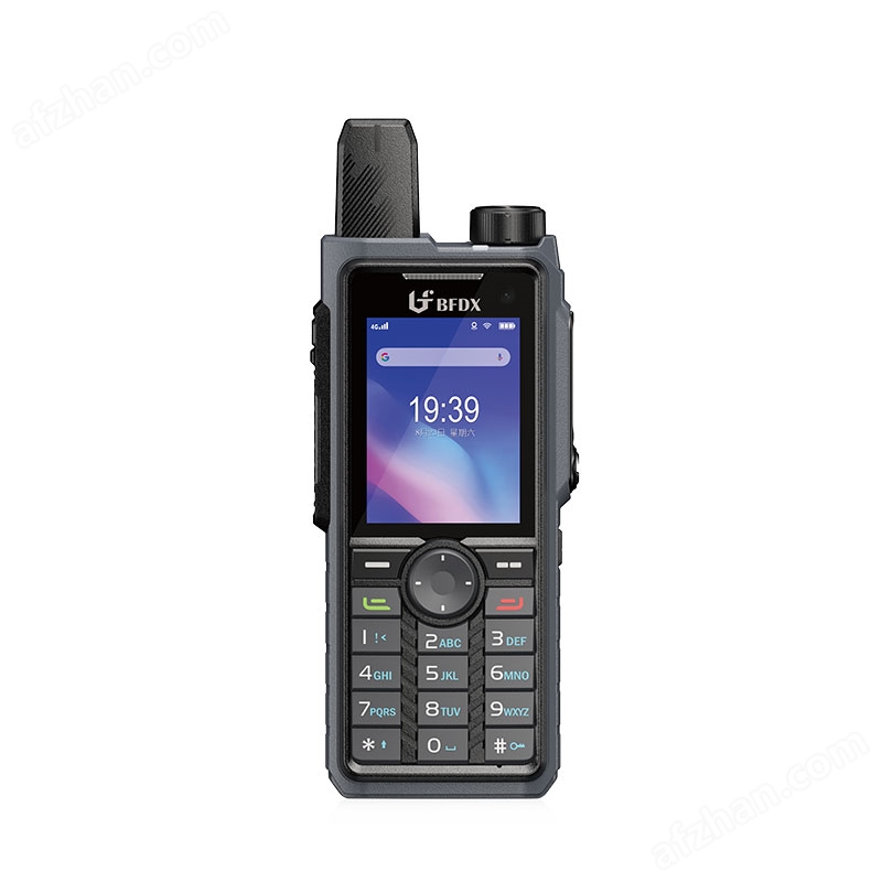
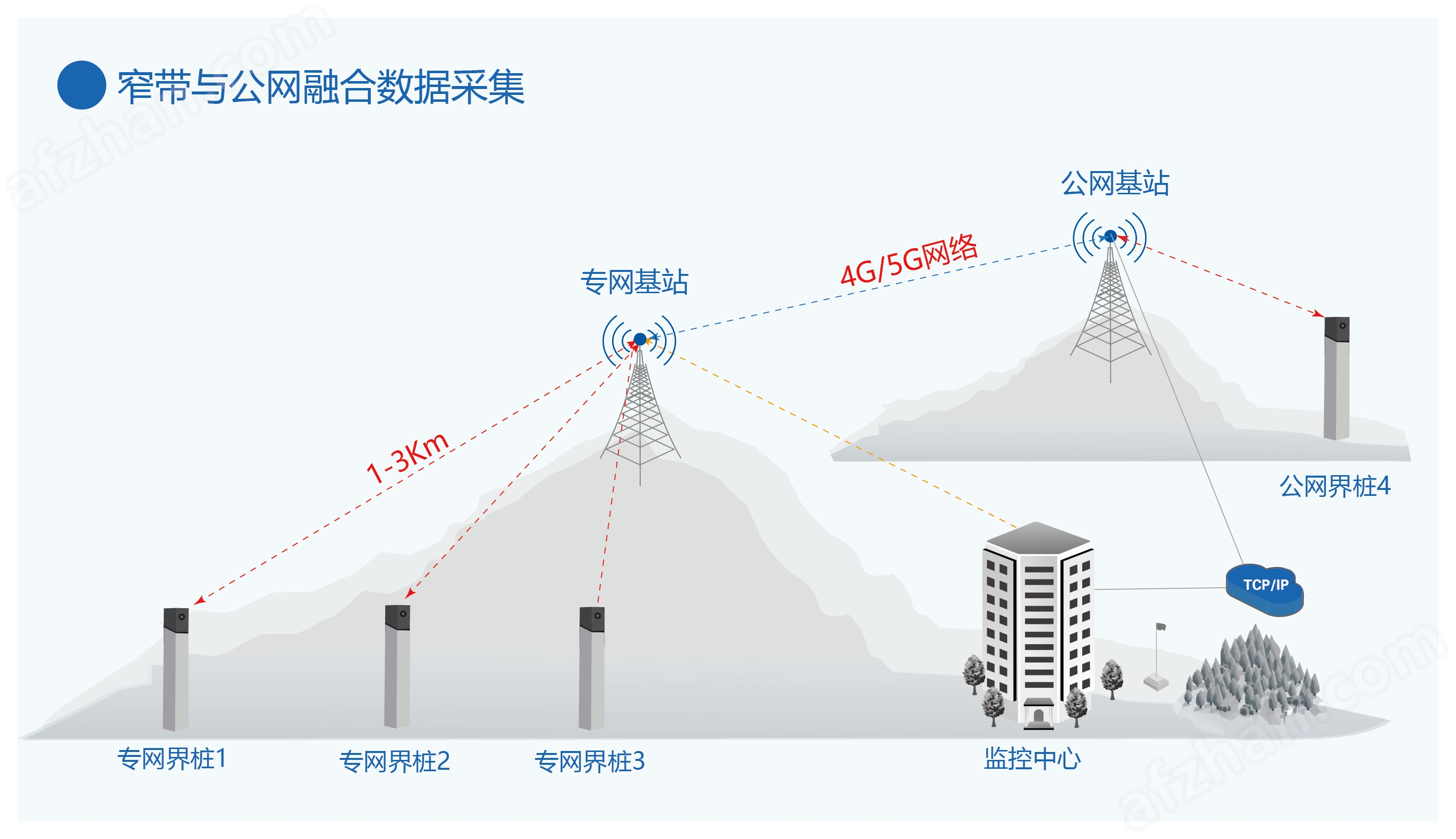
Public and private network integration coverage, full domain data transmission
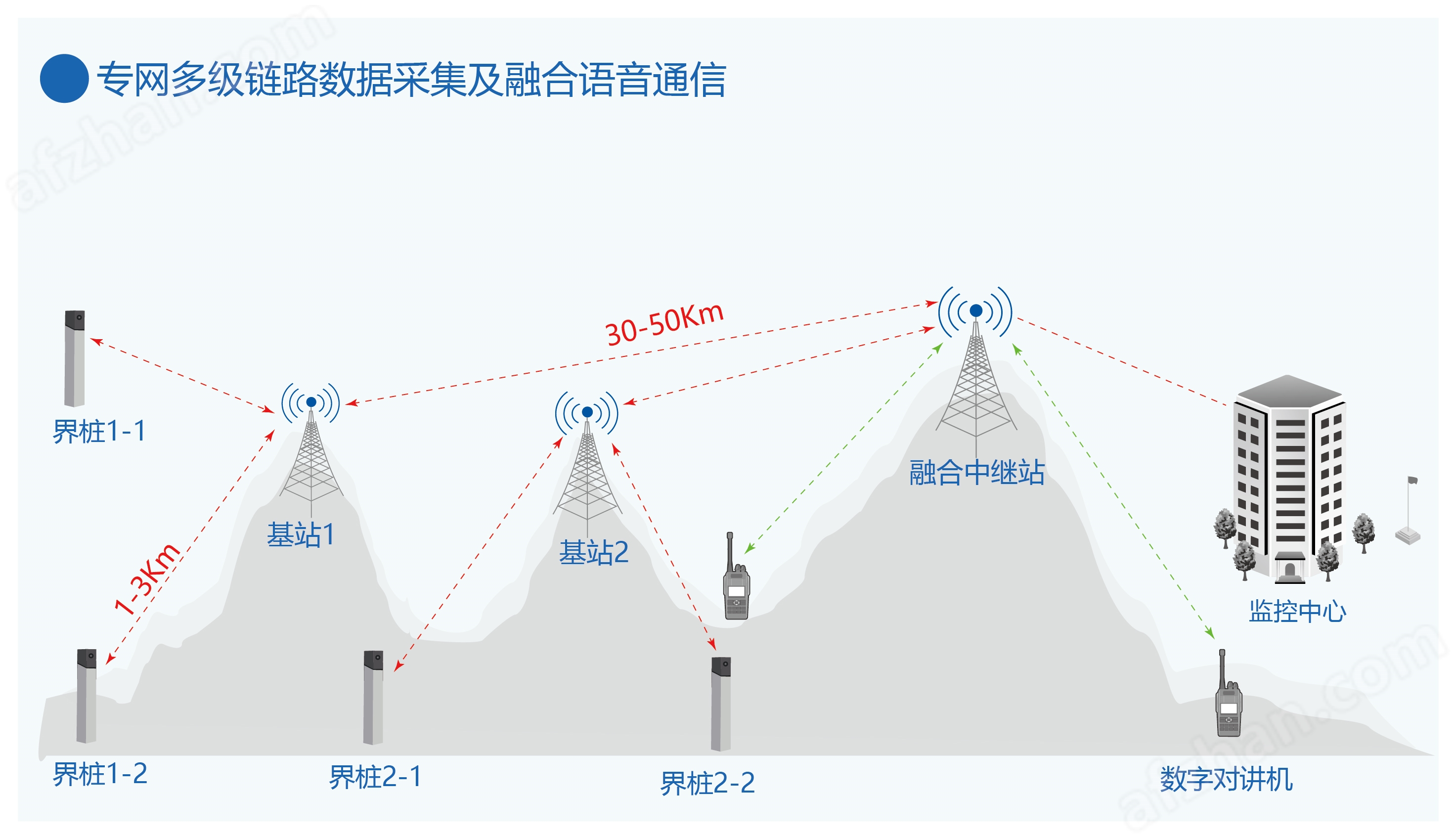
In 4G/5G coverage areas, BF-PMS8110Perimeter intrusion alarm systemDirectly connect to the cloud through the public network and upload monitoring data in real-time; For remote areas without public networks, narrowband DMR private network base stations are deployed to support multi-level relay transmission, with a maximum communication distance of up to 100 kilometers. Combined with photovoltaic solar power supply and lightning protection grounding design, a seamless communication system of "public network+private network" is constructed to ensure stable and reliable data transmission.
Integrated intelligent integration, refined dynamic management
An optional smart pole equipped with a camera, high-frequency broadcast, and LED warning screen can be used to achieve the integration of "monitoring+warning+disposal". When infrared sensing detects personnel approaching, it automatically captures on-site images and pushes them to the management platform, supporting remote voice call warnings and enhancing the front-end handling capabilities of emergencies.
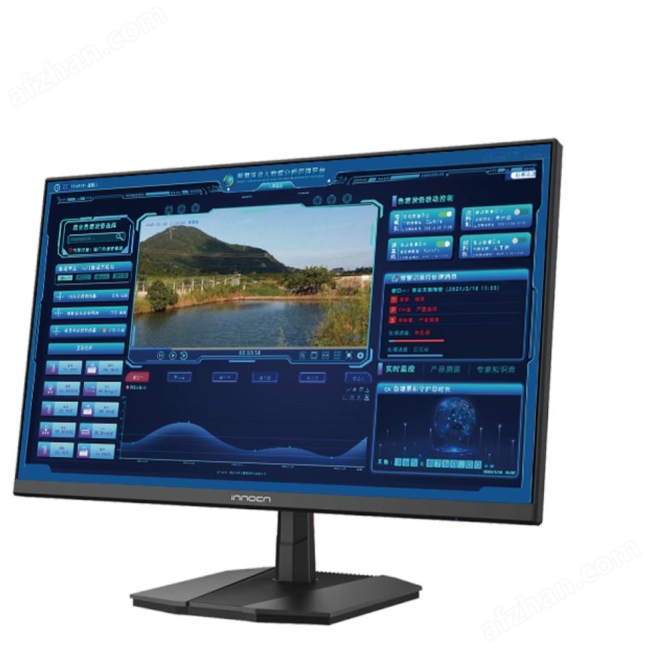
Full scenario management platform, efficient collaborative intelligent decision-making
The GIS map displays the real-time status of terminal devices (online/offline/alarm/low power), automatically pops up alarm information and marks the specific location, supports historical data query, trajectory playback, and statistical report generation. The mobile app provides functions such as inspection check-in, remote parameter configuration, and one click navigation to alarm points, making it convenient for on-site management personnel to respond quickly and improving inspection efficiency by more than 50%. Provide standard API interfaces to support integration with third-party video surveillance, emergency dispatch, environmental monitoring, and other systems, adapting to the management needs of different industries. It can be customized and developed according to user scenarios to achieve multi system data fusion and create a personalized intelligent management platform.
Diversified application scenarios, adapted to the boundary management needs of the entire industry
Land and Regional Boundary Management
Defense/administrative boundaries: Deploy smart boundary markers at provincial, county, and scenic red line areas to monitor the status of boundary facilities in real time, automatically alert for illegal damage incidents, accurately locate with GIS maps, and assist in the rapid resolution of boundary disputes.
Mining area/park perimeter: Intelligent transformation of mining area boundaries and industrial park fences, real-time warning of illegal intrusion, linked video surveillance to lock targets, ensuring regional security and asset integrity.
Infrastructure security protection
Underground pipeline monitoring: Install vibration monitoring terminals along power, gas, and communication pipelines to detect third-party construction damage in real time, with a positioning accuracy of ≤ 10m, and quickly notify inspection personnel to arrive at the site to safeguard the "underground lifeline".
Transportation facility protection: For railway/highway slopes and bridges, real-time warning of geological hazard risks is provided through tilt and displacement monitoring, providing data support for transportation facility maintenance. Ecological and Public Safety Protection
Nature Reserve Management: Deploy infrared sensing and capture devices at the boundaries of wetlands and forest farms to monitor illegal intrusion and wildlife activities, remotely broadcast warnings, and assist in ecological resource protection.
River reservoir monitoring: Combining water level sensors and video surveillance, real-time monitoring of water level anomalies and surrounding activities provides real-time data for flood control, drought resistance, and water resource management.
Urban refined management
Outdoor asset monitoring: Deploy vibration and tilt sensors on ancient trees, cultural relics, billboards, etc., to provide real-time warnings of tipping and theft risks, and achieve intelligent supervision of urban public facilities.